
Sarreguemines Tourisme

Sarreguemines Tourisme

Sarreguemines Tourisme

Sarreguemines Tourisme

Sarreguemines Tourisme

Sarreguemines Tourisme

Sarreguemines Tourisme

Sarreguemines Tourisme

Sarreguemines Tourisme

Sarreguemines Tourisme

Sarreguemines Tourisme
On site, you will find the trail under the following name: LE CHÊNE ET LE ROSEAU
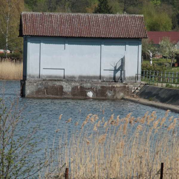
The main interest is the Dieffenbach Lake. The surface of the lake is of 75 hectares and it is one of the ponds in the aquatic Maginot Line. It has been built before the Second World War to serve as a natural border. The area is now a haven for peace and the local fauna, as well as for the aquatic birds, which find shelter there.
Boarded with more than 320 hectares of forest, you will enjoy the riverbanks along the lake. You will love the paths along the banks of the pond, the scent of the undergrowth in autumn or after a summer rain, and the view of the water from between the leaves and reeds. The northern trail loop in the direction of Hoste provides visitors with a magnificent panoramic viewpoint, including an orientation table located at the outskirts of the forest. The picnic table is an ideal location for rest and observation of the beautiful surroundings.
On the northern shore of the lake, an ornithological observatory has been set up in order to observe the local fauna in utmost tranquillity. It is the dreamt of occasion to observe a large plethora of species, which also enjoy the extents of those waters: ducks, geese, herons, moorhens, frogs and toads. Do not forget to pack your binoculars into your backpack so as to be able to fully enjoy the surrounding nature.
- Alternative route: ‘The Reed trail’ (Circuit des roseaux) runs along the banks of the lake, following the brown ring (7.5 km).
- Connections: linked directly to the ‘Along the Bunkers’ trail (Au fil des Blockaus – 5.5 km), with no links. Only a 710 m link to the loop of the Hoste Bas pond. Two links, one of 2.1 km and one of 1.6 km from the southwestern point to the start at the church of Saint-Jean Rohrbach, to take the ‘Around the Marais-Ponds’ trail (Autour de l'Etang des Marais - 11.8 km).
- Trail-Marking: yellow rectangle
- Geographical area: The Blies Valley, confluences of water and history
- Starting points: Diefenbach-lès-Puttelange (annex of Puttelange-aux-Lacs) > rue de la Plage - Pond dike or 104 rue du Lac - parking near the cycling school
Practical information
Fitness / outdoor trails from PUTTELANGE AUX LACS, mode of transport / activity : Walking-related, on the theme(s) : Riverside.
Features of the route
moderate
10 to 15 km
Loop
Distance in kms : 12,2
Duration of the course : 03:10
Altimeter profile
Route line
Visit conditions
Groups accepted on reservation
The course
Contact us
The Oak and the Reed
- contact@sarreguemines-tourisme.com
- 0387988081
- Digue de l'étang de Diefenbach-lès-PuttelangeRue de la Plage57510 PUTTELANGE AUX LACS